NISAR (NASA – ISRO Synthetic Aperture Radar)


Aaditya Deore

NISAR

(NASA – ISRO Synthetic Aperture Radar)


  • Introduction -: NISAR is a joint project of ISRO and NASA to develop the most advanced and futuristic Earth Imaging satellite. NISAR was launched on 30th July, 2025 from Satish Dhawan Space Centre, Srihari Kota, India.


  • Objective -:
  1. To study land and ice deformation, land ecosystem and oceanic regions.
  2. To measure changes on the surface of earth like movement due to earthquake, volcanos, landslides.
  3. To study movement of ice sheets and glaciers.
  4. To track the changes in the extent of crops for agriculture planning and food security.
  5. To monitor climatic changes in Earth’s ecosystem.


  • Features -:
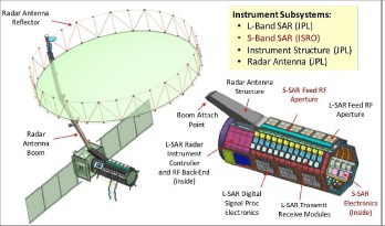
  1. Dual band Radar -: NISAR is the first Earth-observing satellite to use dual frequency SAR system i.e. S-band from ISRO (to study soil moisture in polar regions) and L-band (to study landscape topography and heavily forested areas) from NASA.
  2. SweepSAR Technique -: NISAR uses this to achieve wide image of surface with high resolution.
  3. Interferometric capabilities – It can acquire interferometric data i.e. measure surface of earth with millimetre level precision.
  4. NISAR works for 24*7 in every weather condition because It’s Radar technology can penetrate clouds, fog, and vegetation.
  5. Orbit –: NISAR is mounted at altitude of 747 km in Sun synchronous polar orbit and will complete one revolution in 97 minutes.
  6. Inclination -: NISAR has an orbital inclination of 98.4 degree.
  7. Launch vehicle -: it is launched by GSLV Mark – II (GSLV F-16).
  8. This satellite will scan the entire globe and provide data at 12 days interval.
  9. The data of this satellite will be available free of cost to all by Open Data Policy.


  • Application -:
  1. Climatology – By gatherings data on movement of ice sheets and glaciers to help scientists to understand ice melting pattern and rise in sea level.
  2. Environmental monitoring- it will observe the changes in sea ice on poles to understand global environment pattern.
  3. Geology – It will study tectonic plate movement and land surface deformation due to earthquakes and volcanos.
  4. Disaster Management – By providing data based on changing pattern; risks like earthquake, volcano, landslide, floods, sea level rising etc can be detected.
  5. Biodiversity Conservation -: It will help in monitoring Earth’s ecosystem and changing patterns in forest & wetlands.


  • Significance -:
  1. NISAR highlights ISRO’s growing technological capabilities and its reputation in world.
  2. It will strengthen India-US relations and strategic partnership.
  3. Its open data policy will help in global cooperation in space exploration.
  4. It will contribute in Earth’s dynamics, Climatology, and sustainable development.


  • Conclusion -: NISAR will help to understand Earth better. It will give factual information about climate change, natural disasters, and changes in the environment which will help scientists and leaders to take better steps to protect nature and people. The mission also shows how two countries, India and the USA, can work together for the good of the whole world. With its advanced technology and open data policy, NISAR will play a big role in sustainable development.


  • References -:
  1. https://www.isro.gov.in/NISARSatellite.html
  2. https://www.spacecentre.co.uk/news/space-now-blog/nisar-satellite/
  3. https://science.nasa.gov/mission/nisar/
  4. https://www.isro.gov.in/Mission_GSLVF16_NISAR_Home.html

FOLLOW US